Community Corner
Chasing Waterfalls
Ditch the holiday crowds for one last fall hike while the weather stays mild.
It’s the weekend after Thanksgiving and you need a plan.
Watch more football? Maybe. Dig into some turkey leftovers? Could be tasty. But trekking through crowds at the mall? Not if you can help it.
Time to pack a turkey sandwich, head for the scenic Gold Country and start a new fall tradition by exploring the great outdoors. And what’s better than ending a nature hike with views of a stunning waterfall?
Find out what's happening in Elk Grovewith free, real-time updates from Patch.
Most of the area’s waterfalls are easily accessible, on moderate trails no more than three to four miles round trip. We've chosen several postcard-worthy hikes within about an hour’s drive of Elk Grove. The scenery can be stunning at this time of year as trees start changing colors, so don’t forget your camera.
Auburn
Find out what's happening in Elk Grovewith free, real-time updates from Patch.
● Hidden Falls, about seven miles northwest of Auburn, is a moderate hike to a year-round waterfall. The trail winds through a new regional park that opened in 2006 for hiking, biking and horseback riding. Dogs are allowed on a leash.
The trail is fairly easy, about 3.5 miles round trip through woodlands and rolling hills. In fall, the live oaks turn bright gold as their leaves change. There’s an observation deck for viewing the 30-foot waterfall where Coon Creek drops into a small canyon.
Directions: From Elk Grove, take Highway 99 north and continue on I-80 east. Take the Maple Street exit in Auburn and turn left back over the freeway overpass. Turn left on the frontage road for about two hundred feet and then turn right on Nevada Street. After .9 miles, turn left on Mt. Vernon Road and go three miles. At the T-intersection with Joeger Road, turn left to stay on Mt. Vernon and continue to another 1.1 miles. Turn right on Mears Road. Stay on Mears Road for a half-mile and then turn right into the park. Follow the signs to park at the trailhead.
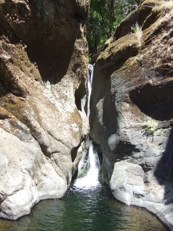
● Black Hole of Calcutta Falls, about 3.6 miles east of Auburn, is a stunning hike above the American River in historic mining country.
The trail has a small elevation climb but isn’t difficult, crossing an old short-gauge railroad overpass called No Hands Bridge before continuing up the canyon. The waterfall cascades down 40 feet of moss-covered granite into a small pool. Make sure to bring a camera. Total round trip distance is about 2.2 miles and dogs are allowed on a leash.
Directions: From Elk Grove, take Highway 99 north and continue on I-80 east. Take the Elm Street exit in Auburn and head south on Highway 49 to the confluence of the North and Middle Forks of the American River. Turn right to stay on Highway 49 toward Cool and travel over the river. Immediately after crossing the bridge, try to find parking on the right side of the highway. Parking can be limited, so arrive early. The trailhead is a green gate next to the bridge and also marks the start of several other trails. Stay to the right and cross No Hands Bridge to continue toward the falls.
Cool
● American Canyon Creek Falls is a moderate hike that follows a firebreak road down a wooded canyon. The trail is moderate and easier in fall because poison oak isn’t as rampant.
American Canyon was the site of a mining camp during the Gold Rush, but most of the ruins are overgrown. The trail is more of a nature walk with a wide variety of plant and animal life. About .75 miles from the trailhead, the American Canyon Trail overlaps briefly with the Western States Trail, blazed by Native Americans and later expanded by miners. The falls are down a side trail about 1.75 miles from the trailhead.
Directions: Follow Highway 49 south from Auburn to the American River Confluence. Turn right across the river to stay on Highway 49 toward Cool for 3.6 miles. In Cool, turn right toward Georgetown on Highway 193 east and drive 5.6 miles before turning left on Pilgrim Way. The trailhead is on the right before the gate for Auburn Lake Trails.
Colfax
● Devils Falls, near the North Fork of the American River, is more of a scenic drive than a hike. There are actually two waterfalls just off the road near a historic suspension bridge.
Since there’s no hike, it doesn’t take much effort to find the waterfalls—the interesting part is driving along the one-lane gravel road to get there. From the road, a short but steep path leads down to the falls over loose rocks and some boulders, so be careful. The falls are beautiful, tumbling down over mossy rocks in a fern-covered glade. There are plenty of good angles for taking photographs.
Directions: From Elk Grove, take Highway 99 north and continue on I-80 east. Take the Canyon Way exit and turn right. After approximately .8 miles, turn left on Yankee Jims Road. Stay left on Yankee Jims and drive five miles. Stay alert—the road is full of tight switchbacks around steep cliffs. Eventually, Yankee Jims Road narrows to one lane and turns to gravel. At about the fifth mile, the road crosses a single-lane bridge over the American River. Past the bridge, drive for another half mile and park.